{short description of image}

SUDAK

Micha Jelisavcic
George Page
John Sloan

TRANSLATE THIS PAGE

Brief Description

This is a report based on information we collected during a visit to Sudak in summer 1997. The city is located on the southeastern coast of Crimea not far from Feodosia. It is easily reached by road from Sevastopol via Simferopol. The Genoese fortress is adjacent to the new town.
The natural setting enhances the dramatic effect this impressive Genoese fortress has for the visitor. It is perched on the crest of a solitary hill shaped like a half cone. The landward hillside is a steep slope, but the seaward side is a sheer, vertical cliff rising hundreds of feet from the water. This hill is set near the center of a short section of gently sloping terrain leading to a beach, between two massive headlands. The coastal section in turn forms a half a bowl, protected from the interior by an arc of high mountains. A view of the valley near Sudak.

The modern town lies on the coast north east of the fortress, which is preserved as an architectural historical monument. Archeological exploration is active and much restoration of walls and towers has been accomplished. The town is now a popular summer beach resort with many of the visual attributes of the Southern California coastline. For information about such visits and future tours please contact Xenophon.

History

Since the summary of the history of Sudak - Sugdai - Sogdalia is being revised continually, it is convenient to place it in a separate file, history.

Map

The general location is shown on the map of the east coast of Crimea. This perspective map shows the terrain view. Here is a diagram of the layout of the castle walls and towers. Plan. Another diagram shows the walls from a different perspective. Diagram. The numbers on the diagram are keyed to the text and photos.

Layout of main structures

{short description of image}

The defensive works consisted of two walls with supporting towers. All construction used local materials, grey limestone, sandstone and cockleshells. The character of the masonry allows us to presume that the Genoese employed local masons, who are also mentioned in the documents. The fortification was erected with the use of cannon in mind, as cannon was coming into use in late medieval Europe of the 14th century. The design conformed to defensive and offensive means of the time when firearms were only beginning. The majority of the defensive structures remain to our time, but some have been repaired or reconstructed. The fortress has two lines. The lower surrounded the town and defended it from enemies. The upper was the citadel and served as the administrative place as well as for defense in case the outer wall was penetrated. But the port was outside these works. It was at the beach south of the fortress mountain and protected from direct attack by an auxiliary wall and towers that blocked the narrow passage between the fortress and the next mountain to the south.
The lower wall is remarkable for its length, over two kilometers. It is in the form of an irregular triangle consisting of massive wall of 6 to 8 meters height and 2 meters thick. It was constructed on a gentle slope near the base of the hill and does not command the adjacent terrain outside the fort. The wall was reenforced by 14 towers (bastions) of open and closed types. One tower is half circular in plan, the rest are rectangular and for the most part have three levels. Of three towers only the foundations remain. Of one other only the lower level remains. The original height of the towers reached 15 meters. The walls have loopholes and in front of the wall there was a moat. The wall rests on the north-east end on a cliff by the sea (towers # 11 and # 12). On the southeast end it is on a ridge over looking the road down to the medieval port. The final tower at this end (# 24) was connected to a tower on the opposite ridge (# 22) by a wall that blocked this road. There was a gate in this wall for the road to the port. This tower was also connected to the end of the upper wall by a wall that has now practically disappeared. Many towers arenamed after the consul who was contemporary with construction and we find their names in Latin inscriptions on stone plaques with heraldric crests from Genoa, Soldai, Kafa and other places.
The main gate entrance to the fortification was located in the middle part of the lower wall at the northwest corner, actually a curved section. It consisted of a large gate under twin towers ( # 2, # 3) and a drawbridge over the moat, covered by a fortified bridgehead (barbican) (# 1). The gate is flanked on the west by the Jakobo Torsello Tower and on the east by the Bernabo di Franki di Pagano Tower, sited at an obtuse angle to each other to give the opportunity in case of necessity to deliver crossfire on all the area before the gate. The over the opening in the gate is an arch coming out of the tower walls at a height of 10.9 meters and supporting a connecting walk between them. In front of the gate is a plaque inscribed with the date of construction, 1389. The gate was closed by a wooden grill (portculus) reenforced by iron coverings. The main gate with attached towers and the bridgehead is the central composition of the lower wall. From the gate the walls extend on each side in two directions toward the seacoast. They form an obtuse angle. There are eight towers in the northeast wall; Bernabo de Franki di Pagano, Pasquali Dzhudich, Unnamed, Round, Lukini de Flisko Lavoni, Corrado Chikalo, and two destroyed towers. In the northwest wall there are six towers; Jakobo Torsello, Corner, Giovanni Marione, Gvarko Rumbal'do, Unnamed and one destroyed.
The upper wall forms a much more powerful inner defense line (# 15 - # 19) at the very top of a steep slope. It consists of the citadel fortress, the Consul's Castle, a wall, two towers (Georgievski and Upper Unnamed, and the Dozorni Tower. The part of the upper wall on the south side from the Upper Unnamed Tower across the face of the cliff to the Corner Tower in the lower wall is almost completely destroyed. There is no more than 10-15 yards between this wall and the sheer cliff over 100 meters straight down to the sea. This is a (view of fortress from a ridge as one approaches from the north. Here is another view showing the entire northeast wall as well as the upper wall and the towers.
Inside the fortress were streets, living quarters, business places, depots, and cultural edifices. Now all that remains on a bare hillside are the mosque, a ruined church, a cistern, and several underground supply storehouses. Below and beside the fortress in the cove southwest of the fortress hill was a ancient port and town. The buildings here are now gone, except for a Byzantine church and the Frederiko Astagver Tower that anchored the defensive wall.
We begin the visit at the main entrance gate with its two towers. outside barbican. And gate under two towers. The gate is defended by the Jakobo Torsello (# 2) and Bernabo di Franki (# 3) Towers. The barbican is a horse shoe shaped semi-circular wall attached to the western side of the two towers. It strengthened the gate defense with its drawbridge over a moat. Only the foundation was remaining except on the northern side, but it is much reconstructed now.
Jakobo Torsello Tower. (# 2) Bernabo di Franki di Pagano Tower (# 3)
They were built to strengthen the defense of the main gate. They are three stories high. Together they provide cross fire covering the barbican. The Jakobo Torsello Tower was built in 1385. On the northern wall is the plaque with date and inscription. It is three stories of open type with only three walls. Inside these there are projections at each level to support the wooden beams on which the cover (floor) rested. There were reenforcements in the walls to prevent their being burst in by the blows of enemy rams. The tower foundations were reenforced. In the tower lowest level there are cut loopholes that look like chinks. In the upper level there are rectangular embrasures with chambers. The tower is topped by machicolations and then teeth shaped merlons. To the west side there is an attached semicircular single story structure with the remains of fireplace. This likely was the guardroom. In 1972 archeological workers inside the tower at a depth of 5 meters uncovered fragments of the wall and tower of pre-Genoese construction. The north wall of the tower is attached to the wall of the barbican. Further restoration work was accomplished in 1977-79.
The Bernabo di Franki di Pagano Tower was built in 1414. The tower was built open on the rear as seen today to prevent use by attackers. (View from inside fortress of rear of towers.) And a close-up view. To the immediate south under the tower is the pre-Genoese foundation. On the northern wall of the Bernabo tower under the loopholes of the lower level there was a flagstone with dated inscription that is now located in the museum in Odessa. Between the levels there were wooden overhead covers (floor of one and ceiling of level below) The floors rested on wood beams that were resting on projections from the walls. The tower has machicolations. At the top level there were tooth-shaped merlons protecting the fighting area on the top floor. There were loopholes in the walls at the lower tier and in the upper tier there were four rectangular windows with embrasures and chambers within.
These two towers formed the center of the lower defensive wall. View of both towers from inside fortress. This view is outside the fortress showing the wall from the front edge of the barbican to the Pasquali tower and the round tower beyond.
Moving along the wall to the north-east we reach the Pasquali Dshudich Tower, (# 7) which was built in 1392. It is on the north-east section of the lower defense wall, about 100 meters from the Bernabo di Franki tower. The tower is also three stories and open in rear, so it has only three sides. There is a glazed flagstone in the west wall with dated inscription. The brickwork of the walls on the inner side is completed with projections for each level on which were laid the wooden beams carrying the floors. There are viewing loopholes in the walls of the lowest level. In the upper level there are rectanglar embrasures. There are shutters on the outside of the tower. At the top are the typical tooth-shaped merlons to protect the troops manning the top level. But now only a couple of the teeth remain in one corner. The fortress wall is united to this tower, which remains in better condition than most.
The Round Tower (# 8) is next. It was built in the 14th-15th centuries on the north east wall. It is the only half-round tower (irregular oval). Some experts believe it dates from the pre-Genoese period. It is open in the rear. The lower level remains intact. Of the second story only the base remains. The stonework shows that on the interior of the walls there were projections for beams to hold the second floor. This view from inside the fortress looks back past the round tower to the Pasquali tower and the gate towers.
The next tower, Lukini di Flisko Lavani, (#10) was built in 1409. It is located on the north east part of the lower wall 123 meters from the Round Tower. The wall connecting the two towers makes a significant curve between them. Between the towers in the walls are located four loopholes. But much of this section of the wall is destroyed. The tower is three stories. The lower level has four walls, but the upper levels have only three (open in rear). The brick work on the inside of the walls show the projections to carry the beams for the wooden floor covering the lowest level. On the second level there are stone lancets. Support for the top level floor is on projections from the walls. This is the only tower with this type of construction. The bottom level has four blank walls (no openings), and there are viewing loopholes with chambers on the second level. The third level has embrasures with chambers. The top of the tower has the usual tooth-shaped merlons. The east wall of the tower was almost completely destroyed as can be seen in this view over the wall. The Corrado Chkalo tower is to the right.
The Corrado Chikalo Tower (# 11) was built in 1404. It is located further long the north-east wall. At first it was the corner tower with an entrance from the wall that joined it to the south. The tower is of closed type and three stories and rectangular. On the first floor there was accomodation without windows. Most likely here was a supply dump of weapons and ammunition. The entrance to the first level is via a stairway inside the tower leading down from the second level. The entrance to the tower is via a doorway in the western wall at the second story, where in wartime the walls had a stone stairway. In the walls of the top floor there are viewing loopholes with chambers. On top are the usual merlons. The floors for the second and third levels were wooden. This view shows both towers. The tower was repaired in 1971.
The Unnamed tower (#12 ) located on the north east corner of the wall was built in 14th-15th centuries. It is two stories high and open on the rear and has only three walls. But it is complete with its merlons. The wooden beams for the upper floor rested on projections from the walls, but for the lower level they rested in sockets in the walls. The second level is connected to the fortress wall by a staircase.
The eastern side of the fortress was independent and could be defended separately. Part is seen in this detailed view. In the section between the unnamed tower and the Corrado Chikalo tower there were four loopholes in 30 meters. A series of loopholes were built in the fortress wall. In case the lower defensive wall was penetrated and the enemy gained entrance to the open space, fire from the Corrado Chikalo tower and the opposite Consul's castle (110 meters off) could cover this area.
Returning to the entrance gate we can then proceed along the north-west section of the lower wall.

We pass a ruined tower whose name is lost. It is 54 meters from the gate. Extensive archeological work was under way in this section as is seen in this view and again here and in a closeup. Then comes the Giovanni Marioni Tower (#27), built in 1388, 63 meters further on. It is located on the north-west part of the lower defense wall 107 meters from the Jakobo Torsello Tower (main gate). On its northern wall is a glazed stone plaque with date and inscription. Under the inscription on the heraldic shield there are three crests. The tower is three stories and open in rear, with only three walls. The brickwork on the inner side has the projections on which wood beams restted to carry the wooden floors. Some of the teeth of the merlons remain.
The Gvarko Rumbal'do Tower (#26) is next. It was built in 1394. The fortress wall 4 meters from the Giovanni Marione tower makes a corner turn of about 80 degrees toward the west and then through 15.5 meters of this corner to the south and after 57 meters is united with the Gvarko Rumbal'do tower. In the northern wall of the tower is a glazed plaque with Latin inscription. Under the text there are three crests on heraldric shields. One depicts a woman in medieval dress. The tower is three stories and open to the rear. It has three walls, but part of the southern wall is destroyed. The brickwork has projections for the beams for the floors. There are loopholes in the lower level and windows with embrasures in the upper level.
There is no surviving data on the next two towers. The next tower (Unnamed, # 25) was built in the 14th - 15th centuries. It is 65 meters from the Gvarko Rumbal'do tower. It was also three stories and open in the rear. Only the foundations remain and the northern wall is without its merlons. There is a plaque with date and inscription on the northern side.
The Corner Tower (#24) was built in 14th - 15th century. It is located on the south-west corner of the fortress. The tower is two stories and open in rear. This tower was joined to three walls, the outer wall from the north, the upper wall that crossed the mountain side and the wall that crossed the valley and protected the port. The brickwork inside the walls has projections for the beams to carry the floors. There are loopholes in the north and west walls. The merlons are atop the walls. This view shows the corner tower from outside the fortress. In 1971 it was repaired.
The Frederik Astagver (Portovaya) Tower (# 22 ) was built in 1386. It is located to the west of the corner tower in the lower wall and was connected to it by the wall across the entrance to the port. This photo shows parts of this wall and towers. On the eastern wall there is a plaque with date and inscription. Under the text are illustrated three crests on a heraldric shield. The tower is three floors and square in plan. It was destroyed on three sides, leaving only the northern wall. The brickwork has the projections on each level for supporting beams. There were loopholes in the second level walls and windows with embrasures on the top level. The entrance to the tower was from the walls connecting it with the Corner Tower. Probably the wall between the Astagver and Corner tower had a gate. Some experts consider that the assistant commandant lived in the Astagver tower. This indicates the importance of this tower in the overall defense of the fortress. This shows the Astagver tower now.
The Church of the Twelve Apostles (# 23) was built in the 14th-15th century. It is located below the fortress wall near the Astagver Tower. It is rectangular in plan. The walls are made of limestone and sandstone blocks with lime mortar. The apse has on the outside 5 borders with facings of well worked out stone designs. It is decorated with 3 carved rosettes. The interior was covered with frescos. Outside was a half circle of free standing banded arches of which only 5 arches remain.
After a climb to the upper defense wall we reach the Consul's tower, (#16) which was built in the 13th - 15th century. It is located on the crest on the sea side in the eastern part of the fortress. The donjon tower is the main part of the Consul's castle . The Consul's castle is the most interesting of the remaining parts of the fortress. It is the most important, most powerful fortification and occupies all the area for defense from the sea. The second powerful corner tower is located to the north east corner of the fortress. Both these towers are connected by the fortress wall forming the interior court in which the entrance is through a special platform with loopholes covering the door from fire. The Consul's tower was an independent, self sustaining fort and was connected by a bridge with the remaining part of the upper level of the defenses. There was located all that was necessary for conducting a prolonged defense and siege. The Consul's tower is square and four stories with simultaneous functions of living quarters, defense, supply of food, water reserves, and most likely an arsenal. On the first floor is located means for storage of food and a cistern for water. One of the ceramic pipes connecting to the cistern goes to the eastern wall and another to the western direction in the thickness of the wall itself. They were used to collect rain water. On the second and third floors the heating is from fireplaces. In the eastern wall of the second floor is a door by which one can go out only by a stairway to the court. The wide stone stairway by which now one enters the tower was built later. In the western wall of this quarters there is still another door, opening on the fortress wall and with the aid of a draw bridge connected to the wall. On the third floor there is a wide Venetian window. In the southern wall there is a door through which by a stairway one can pass directly to the third floor. The cover of the cistern is arched. The upper floor also is arched and under these arches is a combat area protected against attach by toothed merlons and loopholes. The teeth along the perimeter of the tower are set into the inner side of the wall and on the outside there is a cantilever form of two semi-circular archs in belts. (See photo.) To the north and west sides of the tower there were special otkos in the form of a counter force defending the walls from the sea and serving for throwing stones into the side of the enemy. At this end of the citadel there was a unique and distinctive cable system down the face of the cliff. This connected the east edge of the defenses with the seacoast. By means of the rope system the defenders in case of necessity could receive military supplies from the water. And it was by means of this very rope system that in 1475 the last defenders loosing all chance for victory managed to escape to the seacoast and happily sail into the open sea. In 1975- 1980 major restoration work was done on the exterior, the bridge, windows, doors and stairs between floors.
The Georgievski tower (# 17) was built in the 14th - 15th century. It is located in the upper section of the fortress between the Consul's and upper Unnamed Towers and is connected with them by the upper wall. This view shows the upper wall and towers. This photo shows the other side of the wall and the narrow space between it and the cliff. On the Georgievski Tower's western wall is a niche with half circular arch and a small plaque on which is inscribed a high relief depicting a warrior on horseback, presumed to be St George. In the east side of the wall of the tower is a gate through which passed the road from the town to the citadel. The gate was defended by square outer work with sides of 3.7 by 6.6 meters. The fortress wall covered the gate from attack from the side of the town. See detail. The tower is two stories and square in plan with a cutout opening on the side of the gate on north east corner. There are seven loopholes. In the first floor a room served as a chapel. Here were made a series of frescos with illustrations of human figures. The second floor is open to the south side so there were only three walls topped by merlons. Covering the second floor was a wooden floor with beams resting on projections in the walls. In the walls on each level were loopholes. In 1969 the tower was restored.
The upper Unnamed tower (# 18) was built in the 14th -15th century. It is located in the very highest part of the fortress . On the east it is connected by fortress wall to the Georgievski Tower. This photo shows the upper wall between the Georgievski and Unnamed Towers and the Dzorni Tower above. To the west the fortress wall is almost completely ruined to the tower from which is preserved only some fragment. The tower is one story, open. The tower was restored in 1971.
The Dzorni Tower (14-15 Cent) (# 19) is at the very summit of the mountain. It was the lookout tower for the whole fortress and town providing a clear view of all avenues of approach by land and sea. From there one could see the entire country side clear to Au-dag. The tower is an irregular four-sided structure with three levels, but only the lowest level remains. The walls were made of limestone with lime mortar and there were limestone vaults and stairways. On the west side the entrance passage is a narrow corridor with half-circular vaults. It passes out into a large chamber of four irregular sides with loopholes in the east wall. The chamber was covered by vaulting with ribs remaining in the north-east and south-west corners. In the south-west part of the tower there is a remaining chamber without windows or door. The entrance was apparently from above at the level that is no longer remaining. On the walls there are the remanents of frescos. We can surmise that this was a chapel. But some investigators believe that the room was a secret place or that it served as a cistern.
The ancient church (#21 ) was built in the 12th - 14th century. It is located on the side of the mountain below the Dozorni tower. Research in 1973 has shown that it was built not earlier than the 12th century and later rebuilt.
The mosque (# 13) was built in the 13th century, according to the latest information in 1222. It is 14.3 by 13.9 meters. Some researchers consider that the building was rebuilt in 1423 by the Genoese as the Consul's reception hall. Of the original building there remains only the kladka and north east corner and one window with aa that is painted characteristic of Turkish architecture. The dome comes from the beginning of the 14th century. The current portal is from the 16th century. Now the building houses a very fine archeological museum that displays interesting artifacts found in and around the fortress.
The underground structure (# 14) dates from the 14th century. It is located in the eastern part of the fortress near the mosque. The designation is not certain. Some experts consider that it was a cistern for collecting water, but others that it was a prison. It is round in plan and has a covered cupola. The walls
The supply dumps number 1 and 2 (# 4, 5) are from the 14th - 15th century. They are located near the Pasquali Dzhadich tower. In the opinion of one student it was a depot for merchandise, but others think it was a cistern for water. They are rectangular in plan and dug into the ground
Neighboring to the fortress mountain to the west is Bolvan mountain. On it also there was a defensive fortification. And in the valley between the two mountians there was the wall in which was the Astagver tower defending the road down to the sea port and the basin for collecting rain water. Between the Krepostni and Bolvan mountains was a wall. It was part of the town defenses. Between the headlands was a quiet bay. This photo shows part of the modern beach area in this bay with view to south west headland. There was the port suburb with people's homes and the Church of the Twelve Apostles.

Illustrations

We have far too many photographs to place all of them at once on the web site. We will include as many as possible in rotation.

Photo number

Description

{short description of image}

The gate is defended by the Jakobo Torsello (# 2) and Bernabo di Franki (# 3) Towers. The barbican is a horse shoe shaped semi-circular wall attached to the western side of the two towers. It strengthened the gate defense with its drawbridge over a moat. Only the foundation of the barbican wall was remaining except on the northern side, but it is much reconstructed now.

{short description of image}

View of fortress on hill in distance. In the lower wall are the Lukini de Flisko Lavani tower, then left of it the Corrado Chikalo and Unnammed and Corner towers. To the right the gap behind which is dig showing ancient Byzantine wall. Above are the Corner, Consul's, Georgiev, Unnamed and Dozorni Towers.

{short description of image}

Outside wall of barbican with gate towers above.

{short description of image}

This gives a general view of the rear (inside fortress) of the two towers that comprise the entrance gate defensive works. Jakobo Torsello Tower. (# 2) Bernabo di Franki di Pagano Tower (# 3) They were built to strengthen the defense of the main gate. They are three stories high. Together they provide cross fire covering the barbican. The Jakobo Torsello Tower was built in 1385.The Bernabo di Franki di Pagano Tower was built in 1414. On the northern wall is the plaque with date and inscription. It is three stories of open type with only three walls. Inside these there are projections at each level to support the wooden beams on which the cover (floor) rested. There were reenforcements in the walls to prevent their being burst in by the blows of enemy rams. The tower foundations were reenforced. In the tower lowest level there are cut loopholes that look like chinks. In the upper level there are rectangular embrasures with chambers. The tower is topped by machicolations and then teeth shaped merlons. To the west side there is an attached semicircular single story structure with the remains of fireplace. This likely was the guardroom. In 1972 archeological workers inside the tower at a depth of 5 meters uncovered fragments of the wall and tower of pre-Genoese construction. The north wall of the tower is attached to the wall of the barbican. Further restoration work was accomplished in 1977-79.

{short description of image}

Lukini di Flisko Lavani, tower (#10) was built in 1409. It is located on the north east part of the lower wall 123 meters from the Round Tower. The wall connecting the two towers makes a significant curve between them. Between the towers in the walls are located four loopholes. But much of this section of the wall is destroyed. The tower is three stories. The lower level has four walls, but the upper levels have only three (open in rear). The brick work on the inside of the walls show the projections to carry the beams for the wooden floor covering the lowest level. On the second level there are stone lancets. Support for the top level floor is on projections from the walls. This is the only tower with this type of construction. The bottom level has four blank walls (no openings), and there are viewing loopholes with chambers on the second level. The third level has embrasures with chambers. The top of the tower has the usual tooth-shaped merlons. The east wall of the tower was almost completely destroyed as can be seen in this view over the wall. The Corrado Chkalo tower is to the right.

{short description of image}

Upper wall and citadel showing the Unnamed and Dozorni Towers and the Consul's church.

{short description of image}

Close up of gate defense at Georgievski Tower in upper wall and Consul's (Commandant's) tower

{short description of image}

View from top of hill over the outer wall toward mountains in west. Main gate towers are in left-center and Pasquali Dzhudich tower and Unnamed tower at bend in wall are seen over the supply dumps.

{short description of image}

In this view from outside the fortress we see part of the lower city wall as well as most of the inner fortress wall on the crest. The Corrado Chikalo Tower (# 11) on the left here in the lower wall was built in 1404. At first it was the corner tower with an entrance from the wall that joined it to the south. The tower is of closed type and three stories and rectangular. On the first floor there was accomodation without windows. Most likely here was a supply dump of weapons and ammunition. The entrance to the first level is via a stairway inside the tower leading down from the second level. The entrance to the tower is via a doorway in the western wall at the second story, where in wartime the walls had a stone stairway. In the walls of the top floor there are viewing loopholes with chambers. On top are the usual merlons. The floors for the second and third levels were wooden. The tower was repaired in 1971. At the left end of the upper wall is the comandant's tower, the most powerful work in the inner defenses.

{short description of image}

View slightly left of view 9. Lower wall with Luki and Corrado and Unnamed towers and roof of mosque. Consul's tower above.


{short description of image}

View of Sudak - the outer city wall and the inner fotress wall and towers. The dome of a later Turkish mosque is visible at the left side.


{short description of image}

Full view of north-east wall of fortress from the distance.

{short description of image}

Entrance from outside left side of barbican .

{short description of image}

Similar view to # 3 shows outside of barbican

{short description of image}

Gate, inside barbican, Bernabo di Franki and Jakolo Torsello towers.

{short description of image}

This view shows the upper defensive wall from the side next to the sea, which is straight down to the left of the protective railing. Note that the restored merlons and battlement on top of the wall shows that it was defended from this side against enemies who had broken into the lower part of the town and fort. At the upper end of the wall is the unnamed tower. While high above at the very peak is the Dzorni tower. The commandant's tower is behind us.

{short description of image}

This view of the upper - inner- defense wall is from the sea side. The cliff with precipice down to the sea is to the right where the railing is. Here is a local artisan selling his wares to tourists. The comandant's tower is at the center of the photo. When the city was taken the Genoese and their mercenary troops could hold out in this upper defensive work with their backs to the sea. At the final assault by the Turks in 1475 some defenders escaped by going down ropes to ships waiting below.

{short description of image}

View off cliff railing to north and sea past corner of Consul's Tower.

{short description of image}

After a climb to the upper defense wall we reach the Consul's tower, (#16) which was built in the 13th - 15th century. It is located on the crest on the sea side in the eastern part of the fortress. The donjon tower is the main part of the Consul's castle. The Consul's castle is the most interesting of the remaining parts of the fortress. It is the most important, most powerful fortification and occupies all the area for defense from the sea. This view is taken from the inner - that is the sea - side of the donjon tower.

{short description of image}

View down from corner of Consul's tower over mosque toward modern town.

{short description of image}

Mosque and fortress corner with town below.

{short description of image}

View adjacent to #23 shows town.

{short description of image}

View from inside fortress over north-east wall, Corrado tower in center, Lukini de Flisko Tower to left.

{short description of image}

Detail of outer wall just east of the gate.

{short description of image}

View of remains of wall covering entrance to port south west side of fortress between Corner and Astagver Towers.

{short description of image}

The eastern side of the fortress was independent and could be defended separately. Part is seen in this detailed view. In the section between the unnamed tower and the Corrado Chikalo tower there were four loopholes in 30 meters. A series of loopholes were built in the fortress wall. In case the lower defensive wall was penetrated and the enemy gained entrance to the open space, fire from the Corrado Chikalo tower and the opposite Consul's castle (above and behind us in the photo) (110 meters off) could cover this area.

{short description of image}

Detail view of Byzantine foundation next to north-east section of lower wall.

{short description of image}

Archeological exploration of north-west wall near entrance gate.

{short description of image}

View of Crimean mountains and sheltered valley with vinyards on approach to Sudak.

{short description of image}

Wider view of archeological dig, wall and gate towers

{short description of image}

Outside lower north-east wall near barbican, Pasquali Tower visible.

{short description of image}

South-west side of mountain from near port, with citadel on top but out of view.

{short description of image}

View of coast to south-west from medieval port below fortress.

{short description of image}

The Frederik Astagver (Portovaya) Tower (# 22 ) was built in 1386. It is located to the west of the corner tower in the lower wall and was connected to it by the wall across the entrance to the port. The purpose was to block enemies from bypassing the city and fortress and gaining the seacoast behind the fortress. So it is actually outside the circumference of the outer fortress walls. This photo is taken from the path leading to the seaport while looking back landward to the southwest of the fortress.


{short description of image}

Closer view of the Frederik Astagver Tower


{short description of image}

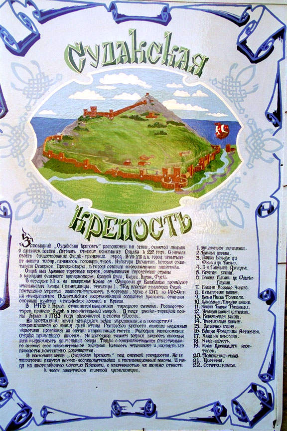
The lower portion of the guide sign.


{short description of image}

Descriptive plaque.

{short description of image}

Upper wall from Georgievski to Unnamed Tower.

{short description of image}

Detail of entrance defenses in gate in upper wall at Georgievski Tower.

{short description of image}

Upper wall and citadel, similar to photo #6.

{short description of image}

View down hill and over outer wall between Pasquali and gate towers.

{short description of image}

Gate towers viewed from above.

{short description of image}

View of sea north east from Consul's keep.

{short description of image}

Inside upper wall shows narrow area from sea cliff between gate and Unnamed towers (like #17 and 18).

{short description of image}

Close up view of upper wall from Consul's Tower past Georgievski to upper unnamed Towers, opposite from # 37.

{short description of image}

The mosque (# 13 on diagram) was built in the 13th century, according to the latest information in 1222. In other words it was a Moslem building before the Genoese captured the city. It is 14.3 by 13.9 meters. However, some researchers consider that the building was rebuilt in 1423 by the Genoese as the Consul's reception hall. Of the original building there remains only the kladka and north east corner and one window with aa that is painted characteristic of Turkish architecture. The dome comes from the beginning of the 14th century. The current portal is from the 16th century. Now the building houses a very fine archeological museum that displays interesting artifacts found in and around the fortress. Note that the fortress lower wall, part of which is seen on the left, passes just behind the mosque. The modern buildings are in the modern Sudak far below the fortress.

{short description of image}

Mosque, now a museum, with unnamed tower and fortress corner beyond.

{short description of image}

View along North east lower wall from above, shows Round Tower just beyond ruined section, Byzantine foundations to left.

{short description of image}

Detail of reconstructed wall showing iron reenforcing bars.

{short description of image}

Exposed Byzantine foundations.

{short description of image}

Rear of two gate towers from inside fortress.

{short description of image}

Close up view of towers similar to #49.

{short description of image}

Detail of archeological dig along north-westwall showin in # 29 and 30.

{short description of image}

Frederik Astagver Tower #23.

{short description of image}

View up mountain from sea at south end with Corner tower #24.

{short description of image}

The Church of the Twelve Apostles (# 23) was built in the 14th-15th century. It is located below the fortress wall near the Astagver Tower. It is rectangular in plan. The walls are made of limestone and sandstone blocks with lime mortar. The apse has on the outside 5 borders with facings of well worked out stone designs. It is decorated with 3 carved rosettes. The interior was covered with frescos. Outside was a half circle of free standing banded arches of which only 5 arches remain. To the left in the background is the corner tower of the main city defensive wall and above it on its right is the edge of the upper crest along which the inner defensive wall used to connect to this corner tower. In this telephoto view the distance between the church and tower appears forshortened. The road to the port ran through the gap between them.

{short description of image}

Diagram showing layout from one angle.

{short description of image}

Diagram showing layout from another angle

{short description of image}

Map of Sudak area in Crimea

{short description of image}

Perspective view of Sudak area

To go to the Xenophon main page for many more illustrated articles about Ukraine, Russia and Crimea please click here.Our expanding series on Russian cities is here.

Return to Top.