| |
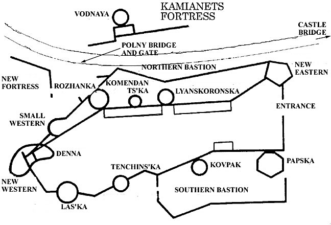
A diagram plan of the castle - fortress
at Kam'yanetz-Podil'ski in Ukraine. This shows the walls and towers of the
medieval castle as reconstructed in first quarter of the 16th century and the
northern and southern bastions that were added later to accomodate artillery..
But there was additional outer bastions and curtains added to the west of the
Novaya and Lyatskaya towers. This work completely blocked the only route to the
castle along the narrow neck of land between the two sections of river. Part of
this shows here as 'novaya krepost'. The 'vodnaya' (water) tower is actually
far below the level of the castle, down between the river bank and the
escarpment. The earliest sections stone of the fortress date from the 11th
century to block the main road into the city, see the remains of the wall with
firing positions in the Denna Tower and the ruins of the Small Oval Tower. But
there were earthen and log fortifications here before that. In the late 14th
century Spyutko Melsztynski, Polish voyevode from Krakow, who owned Kam'yanets,
(1395-99) began a reconstruction. In the middle 15th century the castle was
again rebuilt and ten new towers were built, of which two no longer remain.
Then in the middle 16th century the military engineer, Iov Pretfes, rebuilt
sections including the New Eastern and New Western towers and the Polna Gate
and bridge nearby. Early in the 17th century with artillery coming into use,
Theofil Schomberg, another military engineer, built the stone and earth
bastioned trace fortifications to the west (the New Fortress). In 1672 despite
the modernization, the fortress and city were captured by the Turks. After the
Poles retook the fortress, the northern and southern artillery bastions were
added outside the castle and barracks were built inside it.
|
|