
|
 |
||
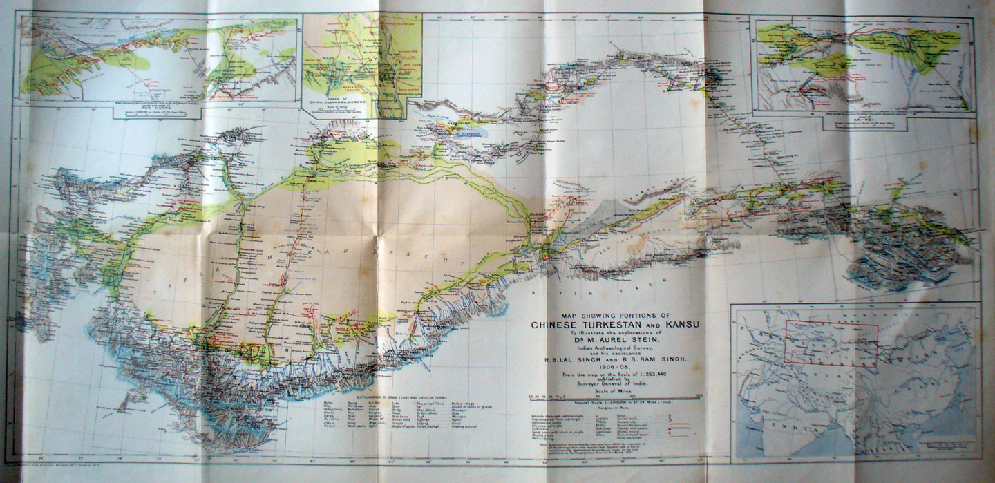
The map of Chinese Turkestan and part of Kansu from Aurel Stein's book on his second expedition. Detailed photos follow. This shows the course of the expedition. It is shown in the red lines. He traveled first north in northern India (Pakistan) into the Wakhan valley of Afghanistan (shown on far left) then turned east into Sarikol and then north through the foothills to Kashgar. From Kashgar he traveled south-east along the border of the Takla Makhan Yarkand and then to Khotan. Then he traveled south into the Kun-lun attempting to reach the headwaters of theYurung-kash river but was blocked by gorges. Returning to Khotan he moved east to revisit Niya and Endere, at both places expanded excavations. Then he traveled along the southeast quarter of the desert to Charchan. From there is stopped briefly at Miran and Abdal before walking north along the western side of the Lop-nor salt dry sea to Lou-lan. Finishing excavation at Lou-lan he returned to Miran to excavate a fort and temple. From Miran he again traveled east along the south side of the Su-lo Ho where he found remains of Han Dynasty wall and towers. He turned south to Tun-huang and the 'caves of the Thousand Buddhas'. He returned to the Han wall and then back to Tun-huang where he acquired a massive quantity of priceless manuscripts and paintings. From there he again went east to An-hsi and then south into the Nan-shan mountains. Leaving the mountains he stopped at Suc-hou and then went into the eastern side of the Nan-shan to find headwaters of the Su-lo Ho and Ku-chou Ho. From Ku-chou city he returned via the main caravan route through Su-chou to An-hsi and then went north- west to Hami and to the Turfan basin. After exploring in the T'ien Shan mountains and valleys he boldly crossed south across the Takla-makan to find the Keriya river and continue to Keriya and Domodo. Back at Khotan he again crossed the Takla-makan - south to north to Aksu. Then he returned to Yarkand. His final travel was east from Yarkand around the Kun-lun and then south to get behind the front range and then west again through the high plateaus and passes shown in the southernmost area of the map. Regaining the main caravan route from Yarkand to Leh he crossed the Karakorum pass shown in the narrow appendige to the south west. |
||